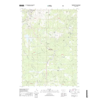
2017 Map of Deadwood South
USGS Topo · Published 2017About this map
The mountain town of Deadwood sits at the northern edge of this high-altitude landscape, where deep drainages like Deadwood Gulch and Whistler Gulch cut through the terrain of the Black Hills National Forest. This 2017 survey shows a region defined by its history of mining and forestry, with settlements such as Galena and Roubaix established near water sources like Bear Butte Creek. The road network, including Gold Dust Trl and Lucky Strike Br 2B, reflects the ongoing importance of access to timber and recreational land. Throughout the area, notable peaks including Pillar Peak and Bear Den Mtn overlook a complex topography of gulches and ridges. Cultural landmarks, such as Galena Cem and Roubaix Cem, provide physical evidence of the early communities that formed around the Black Hills' resource extraction industries.
Find a feature on this map
101 named features on this map. Tap any name to fly to it.
Don’t see what you’re looking for? This feature index may not catch every label — zoom into the map to look around manually.
Map Details
Editions of this 2017 Deadwood South Map
This is the sole edition of this map. No revisions or reprints were ever made.
Other maps of this area

1894 · Deadwood
USGS Topo · 1:125,000

1899 · Sturgis
USGS Topo · 1:62,500

1900 · Spearfish
USGS Topo · 1:62,500

1901 · Deadwood
USGS Topo · 1:125,000

1915 · Spearfish
USGS Topo · 1:62,500

1915 · Sturgis
USGS Topo · 1:62,500

1916 · Deadwood
USGS Topo · 1:125,000

1953 · Nemo
USGS Topo · 1:24,000

1953 · Rapid City
USGS Topo · 1:250,000
1954 · Deadman Mountain
USGS Topo · 1:24,000