
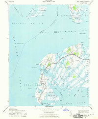
1942 Map of Deal Island
USGS Topo · Published 1958About this map
Deal Island and its surrounding watermen communities sit at the edge of Tangier Sound during the early 1940s, a period when the local economy was deeply tied to the Chesapeake Bay. This military-derived survey illustrates the intricate network of tidal thoroughfares, including the Upper Thorofare and Lower Thorofare, which define the island's geography. The presence of multiple aids to navigation, such as the Sharkfin Shoal Lighthouse and Haines Point Light, highlights the importance of safe passage through these treacherous shoals for fishing vessels. Settlements like Wenona and Chance are shown concentrated along the few hard-surfaced roads, while the vast Dames Quarter Marsh and Clay Island Marsh reflect the area's natural state before modern drainage or development patterns altered the tidewater landscape.
Find a feature on this map
59 named features on this map. Tap any name to fly to it.
Don’t see what you’re looking for? This feature index may not catch every label — zoom into the map to look around manually.
Map Details
Editions of this 1942 Deal Island Map
2 editions found
Other maps of this area

1898 · St. Marys
USGS Topo · 1:125,000

1903 · Nanticoke
USGS Topo · 1:62,500

1903 · Bloodsworth Island
USGS Topo · 1:62,500

1903 · Deal Island
USGS Topo · 1:62,500

1905 · Crapo
USGS Topo · 1:62,500

1906 · St. Marys
USGS Topo · 1:125,000

1942 · Terrapin Sand Point
USGS Topo · 1:24,000

1942 · Kedges Straits
USGS Topo · 1:24,000

1942 · Bloodsworth Island
USGS Topo · 1:24,000

1942 · Marion
USGS Topo · 1:24,000