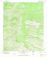
1968 Map of Dean Peak
USGS Topo · Published 1971About this map
The Hualapai Mountains define this high-altitude landscape in Mohave County, where mining activity and remote ranching outposts are scattered across complex terrain. Surveyed in the late 1960s, the map identifies several distinct mining operations, including the Standard Mineral Mine to the north and the Gold King Mine tucked into the southern drainages. These sites, along with the Democrat Mine and Musa Giant Mine, reflect the region's long history of mineral exploration.
Find a feature on this map
34 named features on this map. Tap any name to fly to it.
Don’t see what you’re looking for? This feature index may not catch every label — zoom into the map to look around manually.
Map Details
Editions of this 1968 Dean Peak Map
3 editions found
Other maps of this area

1886 · Diamond Creek
USGS Topo · 1:250,000

1892 · Diamond Creek
USGS Topo · 1:250,000

1923 · Signal
USGS Topo · 1:250,000

1942 · Signal
USGS Topo · 1:250,000

1948 · Williams
USGS Topo · 1:250,000

1950 · Prescott
USGS Topo · 1:250,000

1954 · Prescott
USGS Topo · 1:250,000

1954 · Williams
USGS Topo · 1:250,000

1956 · Williams
USGS Topo · 1:250,000

1958 · Prescott
USGS Topo · 1:250,000