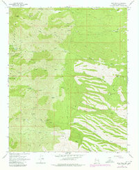
1968 Map of Dean Peak
USGS Topo · Published 1980About this map
Hualapai Mountain County Park and its surrounding peaks define this arid landscape during the late 1960s. High-altitude landmarks like Dean Peak and the settlement at Pine Lake provide context for a region defined by its verticality and scarce water resources. The map documents a complex network of pack trails and jeep trails that connect various springs and tanks essential for survival in the high desert, such as New Years Cabin Spring and the Wooden Tower Tank.
Find a feature on this map
33 named features on this map. Tap any name to fly to it.
Don’t see what you’re looking for? This feature index may not catch every label — zoom into the map to look around manually.
Map Details
Editions of this 1968 Dean Peak Map
3 editions found
Other maps of this area

1886 · Diamond Creek
USGS Topo · 1:250,000

1892 · Diamond Creek
USGS Topo · 1:250,000

1923 · Signal
USGS Topo · 1:250,000

1942 · Signal
USGS Topo · 1:250,000

1948 · Williams
USGS Topo · 1:250,000

1950 · Prescott
USGS Topo · 1:250,000

1954 · Prescott
USGS Topo · 1:250,000

1954 · Williams
USGS Topo · 1:250,000

1956 · Williams
USGS Topo · 1:250,000

1958 · Prescott
USGS Topo · 1:250,000