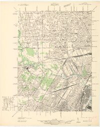
1936 Map of Dearborn
USGS Topo · Published 1936About this map
The industrial and civic expansion of Dearborn is captured here during the mid-1930s, showing the significant footprint of the Ford motor interests on the Michigan landscape. The map details the expansive Ford Airport, complete with its Mooring Mast, and the nearby Ford Rotunda, highlighting the area's role as a global center of automotive innovation. Adjacent to these sites, the historical reconstructions at Greenfield Village stand in contrast to the dense residential grids beginning to fill Detroit and Melvindale.
Find a feature on this map
138 named features on this map. Tap any name to fly to it.
Don’t see what you’re looking for? This feature index may not catch every label — zoom into the map to look around manually.
Map Details
Editions of this 1936 Dearborn Map
This is the sole edition of this map. No revisions or reprints were ever made.
Other maps of this area

1905 · Wayne
USGS Topo · 1:62,500

1905 · Detroit
USGS Topo · 1:62,500

1906 · Wyandotte
USGS Topo · 1:62,500

1906 · Romulus
USGS Topo · 1:62,500

1912 · Wyandotte
USGS Topo · 1:62,500

1912 · Wayne
USGS Topo · 1:62,500

1918 · Detroit
USGS Topo · 1:62,500

1924 · Detroit
USGS Topo · 1:62,500

1928 · Romulus
USGS Topo · 1:62,500

1929 · Wyandotte
USGS Topo · 1:62,500