1961 Map of Death Valley
USGS Topo · Published 1961About this map
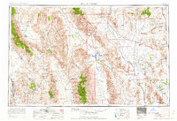
Death Valley National Monument and the surrounding desert landscapes are documented here during a period of intense Cold War activity and established mining history. This 1961 revision highlights the industrial and military footprint in the region, featuring the Nevada Proving Grounds and Camp Desert Rock alongside the US Naval Ordnance Test Station. The map illustrates the specialized infrastructure of the era, from the Meteorological Station to the Park Village Pipeline Service Road.
Find a feature on this map
203 named features on this map. Tap any name to fly to it.
Don’t see what you’re looking for? This feature index may not catch every label — zoom into the map to look around manually.
Map Details
Editions of this 1961 Death Valley Map
This is the sole edition of this map. No revisions or reprints were ever made.
Other maps of this area

1905 · Olancha
USGS Topo · 1:125,000

1906 · Kernville
USGS Topo · 1:125,000

1907 · Olancha
USGS Topo · 1:125,000

1907 · Mt. Whitney
USGS Topo · 1:125,000

1907 · Las Vegas
USGS Topo · 1:250,000

1908 · Kawich
USGS Topo · 1:250,000

1908 · Lida
USGS Topo · 1:250,000

1908 · Furnace Creek
USGS Topo · 1:250,000

1908 · Las Vegas
USGS Topo · 1:250,000

1908 · Kernville
USGS Topo · 1:125,000