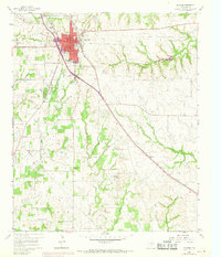
1960 Map of Decatur
USGS Topo · Published 1969About this map
Decatur serves as the focal point of this Wise County study, showing the city's northward expansion as of the late 1960s. The presence of Decatur College and several outlying rural congregations, such as St John Ch and Pleasant Grove Church No 1, indicates a well-established community structure. The Fort Worth and Denver railroad cuts diagonally across the landscape, paralleling a major highway corridor marked as Under Construction, reflecting the era's significant infrastructure development.
Find a feature on this map
25 named features on this map. Tap any name to fly to it.
Don’t see what you’re looking for? This feature index may not catch every label — zoom into the map to look around manually.
Map Details
Editions of this 1960 Decatur Map
3 editions found
Other maps of this area

1924 · Sunset 4-d
USGS Topo · 1:48,000

1930 · Boyd
USGS Topo · 1:62,500

1954 · Sherman
USGS Topo · 1:250,000

1958 · Sherman
USGS Topo · 1:250,000

1960 · Bridgeport East
USGS Topo · 1:24,000

1960 · Decatur
USGS Topo · 1:24,000

1960 · Boyd
USGS Topo · 1:24,000

1960 · Cottondale
USGS Topo · 1:24,000

1960 · Bluett
USGS Topo · 1:24,000

1960 · Rhome
USGS Topo · 1:24,000