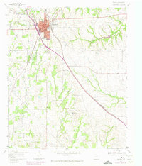
1960 Map of Decatur
USGS Topo · Published 1974About this map
Decatur serves as the focal point of this Wise County study, showing the city's residential and commercial expansion south toward Decatur College. The landscape is defined by the Burlington Northern railroad corridor, which angles southeast through the prairie toward the small community of Herman. Away from the urban center, the terrain is marked by a network of rural landmarks and early gathering places. Genealogists will find numerous country houses of worship, including New Salem Ch, Pleasant Grove Church No 1, and Bell Ch. The map also preserves the locations of local burial grounds such as Bethel Cem and Sand Hill Cem, situated near prominent elevations like Sand Hill and Pat Dick Hill. Drainage patterns are dictated by several waterways, notably Sweetwater Creek, Walnut Creek, and Oliver Creek, which carve through the central Texas fields.
Find a feature on this map
23 named features on this map. Tap any name to fly to it.
Don’t see what you’re looking for? This feature index may not catch every label — zoom into the map to look around manually.
Map Details
Editions of this 1960 Decatur Map
3 editions found
Other maps of this area

1924 · Sunset 4-d
USGS Topo · 1:48,000

1930 · Boyd
USGS Topo · 1:62,500

1954 · Sherman
USGS Topo · 1:250,000

1958 · Sherman
USGS Topo · 1:250,000

1960 · Bridgeport East
USGS Topo · 1:24,000

1960 · Decatur
USGS Topo · 1:24,000

1960 · Boyd
USGS Topo · 1:24,000

1960 · Cottondale
USGS Topo · 1:24,000

1960 · Bluett
USGS Topo · 1:24,000

1960 · Rhome
USGS Topo · 1:24,000