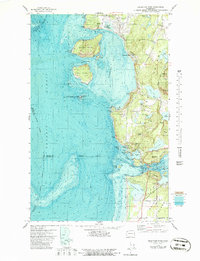
1978 Map of Deception Pass
USGS Topo · Published 1986About this map
Anacortes anchors the northern end of this coastal survey, where the landscape transitions from the urban corporate boundary to the high, varied terrain of Whidbey Island. The geography is defined by the narrow, high-current corridor of Deception Pass and Canoe Pass, which separate the islands and create a complex network of bays such as Bowman Bay and Cornet Bay. The topographic and bathymetric data reveal a rugged shoreline where steep summits like Mt Erie and Sugarloaf rise abruptly from the waters of Rosario Strait.
Find a feature on this map
76 named features on this map. Tap any name to fly to it.
Don’t see what you’re looking for? This feature index may not catch every label — zoom into the map to look around manually.
Map Details
Editions of this 1978 Deception Pass Map
This is the sole edition of this map. No revisions or reprints were ever made.
Other maps of this area

1943 · Richardson
USGS Topo · 1:62,500

1943 · Orcas Island
USGS Topo · 1:62,500

1943 · Deception Pass
USGS Topo · 1:62,500

1943 · Anacortes
USGS Topo · 1:62,500

1951 · Deception Pass
USGS Topo · 1:62,500

1951 · Anacortes
USGS Topo · 1:62,500

1957 · Richardson
USGS Topo · 1:62,500

1957 · Orcas Island
USGS Topo · 1:62,500

1957 · Victoria
USGS Topo · 1:250,000

1973 · Cypress Island
USGS Topo · 1:24,000