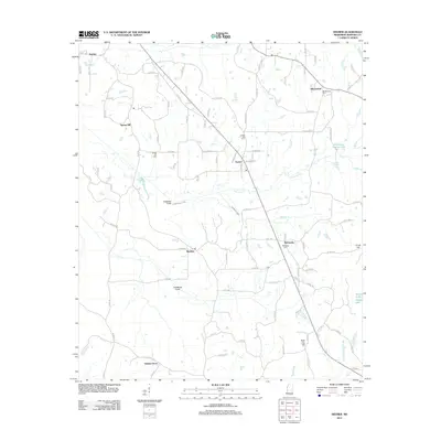
2012 Map of Deemer
USGS Topo · Published 2012About this map
The community of Tucker and the surrounding Choctaw Indian Reservation lands define this portion of Neshoba County in the early 21st century. The landscape is marked by a network of BIA roads and county routes that connect established settlements such as Spring Hill, Bloomfield, and Bethsaida. Water management is a prominent feature of the terrain, visible through engineered waterways like the Cushtusia Canal and Coonshuck Canal, which reflect efforts to drain and manage the low-lying areas near Cushtusia Cr. Local heritage is anchored by several burial grounds, including Spring Hill Cem, Center Hill Cem, and Bethesda Cem, providing critical landmarks for genealogical research in this rural corridor. From the northern edge at Deemer down to the southern reaches of Golden Grove, the map illustrates a landscape of scattered homesteads, small lakes like House Lake, and the winding course of Blinker Cr.
Find a feature on this map
95 named features on this map. Tap any name to fly to it.
Don’t see what you’re looking for? This feature index may not catch every label — zoom into the map to look around manually.
Map Details
Editions of this 2012 Deemer Map
This is the sole edition of this map. No revisions or reprints were ever made.
Other maps of this area

1953 · Meridian
USGS Topo · 1:250,000

1957 · Meridian
USGS Topo · 1:250,000

1962 · House
USGS Topo · 1:24,000

1962 · Owl Creek
USGS Topo · 1:24,000

1962 · Post
USGS Topo · 1:24,000

1965 · Meridian
USGS Topo · 1:250,000

1972 · Pearl River
USGS Topo · 1:24,000

1972 · Deemer
USGS Topo · 1:24,000

1972 · Union East
USGS Topo · 1:24,000
1972 · Philadelphia
USGS Topo · 1:24,000