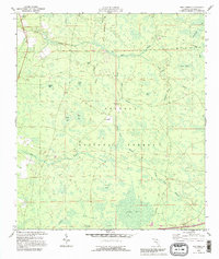
1994 Map of Deep Creek
USGS Topo · Published 1995About this map
Osceola National Forest dominates this landscape in northern Columbia County, Florida, revealing a complex network of wetlands and pine flatwoods. The map detail shows the rural character of the area in the mid-1990s, anchored by the community of Greenfield and the eponymous Deep Creek. This survey records a geography defined by its bays and heads, such as Otter Bay, Impassable Bay, and Sawgrass Head.
Find a feature on this map
34 named features on this map. Tap any name to fly to it.
Don’t see what you’re looking for? This feature index may not catch every label — zoom into the map to look around manually.
Map Details
Editions of this 1994 Deep Creek Map
2 editions found
Other maps of this area

1954 · Valdosta
USGS Topo · 1:250,000

1958 · Valdosta
USGS Topo · 1:250,000

1959 · Valdosta
USGS Topo · 1:250,000

1961 · Deep Creek
USGS Topo · 1:24,000

1961 · White Springs East
USGS Topo · 1:24,000

1962 · Lake City East
USGS Topo · 1:24,000

1963 · Olustee
USGS Topo · 1:24,000

1963 · Lake City West
USGS Topo · 1:24,000

1969 · Sanderson NW
USGS Topo · 1:24,000
1969 · Benton
USGS Topo · 1:24,000