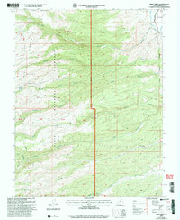
2002 Map of Deep Creek
USGS Topo · Published 2005About this map
The Sevier Plateau dominates this high-altitude landscape in Garfield County, showcasing a complex network of drainages and mountain peaks. The Dixie National Forest boundary encompasses most of the terrain, where Table Mountain and Mount Dutton stand as significant topographic landmarks. Water management and natural flow are central to the area's character, with the East Fork Sevier River and the Antimony Canal appearing in the northeast corner near the Antimony corporate boundary. This 2002 revision provides a look at the wilderness and land management of the era, including established routes like Hoodle Creek and Willow Creek. Distinctive features such as a Communication Site on a ridge and numerous springs like Pole Spring reflect the region's utility for both modern infrastructure and livestock grazing.
Find a feature on this map
36 named features on this map. Tap any name to fly to it.
Don’t see what you’re looking for? This feature index may not catch every label — zoom into the map to look around manually.
Map Details
Editions of this 2002 Deep Creek Map
This is the sole edition of this map. No revisions or reprints were ever made.
Other maps of this area

1885 · Beaver
USGS Topo · 1:250,000

1885 · Fish Lake
USGS Topo · 1:250,000

1886 · Kanab
USGS Topo · 1:250,000

1886 · Escalante
USGS Topo · 1:250,000

1896 · Fish Lake
USGS Topo · 1:250,000

1953 · Richfield
USGS Topo · 1:250,000

1953 · Cedar City
USGS Topo · 1:250,000

1956 · Escalante
USGS Topo · 1:250,000

1956 · Salina
USGS Topo · 1:250,000

1958 · Richfield
USGS Topo · 1:250,000