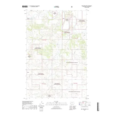
2020 Map of Deep Creek North
USGS Topo · Published 2020About this map
The Little Missouri River meanders through the Badlands landscape of Slope County, defining much of the drainage pattern in this sparsely populated stretch of western North Dakota. This section of the Little Missouri National Grassland is deeply dissected by a network of seasonal watercourses, including Deep Cr and Spring Coulee, which flow toward the primary river channel. The topographic detail highlights the intricate drainage breaks and plateau edges that characterize this region's geology. Evidence of human infrastructure is limited to a few arterial routes like E River Rd and secondary section-line roads such as 55th St SW and 58th St SW. The map provides a clear look at the public land boundaries within townships T136N and T135N, where federal land management dominates the geography.
Find a feature on this map
14 named features on this map. Tap any name to fly to it.
Don’t see what you’re looking for? This feature index may not catch every label — zoom into the map to look around manually.
Map Details
Editions of this 2020 Deep Creek North Map
This is the sole edition of this map. No revisions or reprints were ever made.
Other maps of this area

1953 · Dickinson
USGS Topo · 1:250,000

1957 · Dickinson
USGS Topo · 1:250,000

1961 · Rocky Ridge
USGS Topo · 1:62,500

1973 · Black Butte
USGS Topo · 1:24,000

1979 · Deep Creek North
USGS Topo · 1:24,000

1979 · Bullion Butte
USGS Topo · 1:24,000

1980 · Spring Creek
USGS Topo · 1:24,000

1980 · Belfield
USGS Topo · 1:100,000

1981 · Bowman
USGS Topo · 1:100,000
1982 · Cliffs Plateau
USGS Topo · 1:24,000