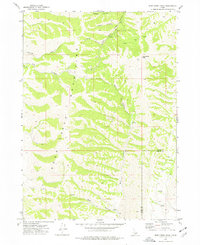
1973 Map of Deep Creek Peak
USGS Topo · Published 1977About this map
The Deep Creek Mountains dominate this 1970s landscape, centered on the high point of Deep Creek Peak. The survey reveals a complex system of drainage and relief across the border of Power Co and Oneida Co, where the high ridges are incised by numerous named corridors such as Wheeler Canyon, Bull Canyon, and Reservoir Canyon. These features illustrate the natural water management of the region, including the Left Fork and various unnamed springs that feed into the larger basins.
Find a feature on this map
15 named features on this map. Tap any name to fly to it.
Don’t see what you’re looking for? This feature index may not catch every label — zoom into the map to look around manually.
Map Details
Editions of this 1973 Deep Creek Peak Map
This is the sole edition of this map. No revisions or reprints were ever made.
Other maps of this area

1934 · Rockland
USGS Topo · 1:62,500

1937 · Rockland
USGS Topo · 1:62,500

1938 · Pauline
USGS Topo · 1:48,000

1944 · Arbon
USGS Topo · 1:62,500

1954 · Pocatello
USGS Topo · 1:250,000

1958 · Pocatello
USGS Topo · 1:250,000

1971 · Rockland East
USGS Topo · 1:24,000

1971 · Bannock Peak
USGS Topo · 1:24,000
1971 · Pauline
USGS Topo · 1:24,000
1973 · Arbon
USGS Topo · 1:24,000