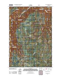
2011 Map of Deep Creek
USGS Topo · Published 2011About this map
The Grande Ronde River carves a path through the northern reaches of this Union County landscape, defining a terrain shaped by deep drainage systems and high meadows. This area is characterized by a series of high-elevation openings, including Newman Meadows, Brown Meadows, and Grove Meadow, which historically served as vital landmarks for navigation and seasonal land use. The drainage network is complex, with Grossman Creek and East Grossman Creek feeding into the larger system near Indian Point. In the southern portion of the quadrangle, Clear Creek and Deep Creek intersect a winding road network, most notably Brown Rd, providing insight into the remote access points used by foresters and local travelers in the early 21st century. The map illustrates the fundamental relationship between the high plateau meadows and the steep watercourses that drain toward the river.
Find a feature on this map
11 named features on this map. Tap any name to fly to it.
Don’t see what you’re looking for? This feature index may not catch every label — zoom into the map to look around manually.
Map Details
Editions of this 2011 Deep Creek Map
This is the sole edition of this map. No revisions or reprints were ever made.
Other maps of this area

1955 · Grangeville
USGS Topo · 1:250,000

1959 · Grangeville
USGS Topo · 1:250,000

1964 · Howard Butte
USGS Topo · 1:24,000

1964 · Akers Butte
USGS Topo · 1:24,000

1964 · Rondowa
USGS Topo · 1:24,000

1967 · Fry Meadow
USGS Topo · 1:24,000

1967 · Eden
USGS Topo · 1:24,000

1967 · Elbow Creek
USGS Topo · 1:24,000

1967 · Promise
USGS Topo · 1:24,000
1967 · Deep Creek
USGS Topo · 1:24,000