
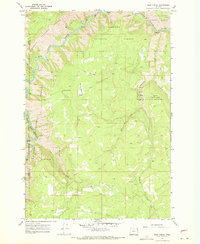
1967 Map of Promise
USGS Topo · Published 1971About this map
Promise sits atop the high ground of the Wallowa National Forest during the late 1960s, serving as a focal point for this rural Wallowa County landscape. The settlement is marked by a small Cem and is connected to the surrounding wilderness by the winding Promise Road. To the northwest, the Grande Ronde River carves a deep path through the canyon, while the interior is defined by elevated plateaus like Ray Flat and McNutt Flat.
Find a feature on this map
26 named features on this map. Tap any name to fly to it.
Don’t see what you’re looking for? This feature index may not catch every label — zoom into the map to look around manually.
Map Details
Editions of this 1967 Promise Map
This is the sole edition of this map. No revisions or reprints were ever made.
Other maps of this area

1955 · Grangeville
USGS Topo · 1:250,000

1957 · Sled Springs
USGS Topo · 1:62,500

1959 · Grangeville
USGS Topo · 1:250,000

1964 · Howard Butte
USGS Topo · 1:24,000

1964 · Akers Butte
USGS Topo · 1:24,000

1967 · Wood Butte
USGS Topo · 1:24,000

1967 · Troy
USGS Topo · 1:24,000

1967 · Eden
USGS Topo · 1:24,000

1967 · Elbow Creek
USGS Topo · 1:24,000
1967 · Deep Creek
USGS Topo · 1:24,000