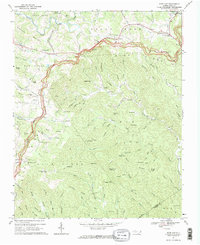
1967 Map of Deep Gap
USGS Topo · Published 1969About this map
Blue Ridge Parkway curves across the high crests of this landscape, tracing the continental divide through the mountains of Watauga County. The survey shows a region defined by high-altitude ridges and deep drainages, including Blue Ridge and Osborne Mtn. Small communities and family-named homesteads are scattered along the winding roads, with Bamboo, Triplett, and Aho serving as local hubs. Religious life is well-documented through numerous country churches such as Laurel Springs Ch and the Holy Trinity Chapel near Deep Gap.
Find a feature on this map
112 named features on this map. Tap any name to fly to it.
Don’t see what you’re looking for? This feature index may not catch every label — zoom into the map to look around manually.
Map Details
Editions of this 1967 Deep Gap Map
2 editions found
Other maps of this area

1889 · Wilkesboro
USGS Topo · 1:125,000

1891 · Wilkesboro
USGS Topo · 1:125,000

1893 · Cranberry
USGS Topo · 1:125,000

1895 · Cranberry
USGS Topo · 1:125,000

1899 · Cranberry
USGS Topo · 1:125,000

1902 · Cranberry
USGS Topo · 1:125,000

1934 · Boone
USGS Topo · 1:24,000

1935 · Zionville
USGS Topo · 1:24,000

1936 · Blowing Rock
USGS Topo · 1:48,000
1939 · Zionville
USGS Topo · 1:24,000