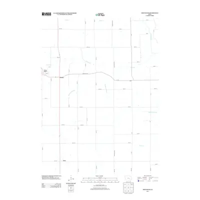
2013 Map of Deep River
USGS Topo · Published 2013About this map
Deep River serves as the primary hub in this corner of Poweshiek County, where the town's grid of streets like Main ST and 7th ST meets the surrounding agricultural landscape. The area is defined by a dense network of sectional roads and the meandering paths of several significant waterways, including the Middle English River and the N English River to the northeast. Small outlying settlements like Dresden and Tilton sit along the primary north-south corridor, while Hedge marks a point of interest further east along the Poweshiek-Iowa Rd. The map reveals a highly structured drainage system where minor tributaries like Jordan Cr and Gritter Cr feed into the larger river basins. This 2013 survey illustrates the modern layout of the rural Midwest, where long-standing trails like Diamond Trail Rd continue to shape the movement between farmsteads and the central township.
Find a feature on this map
49 named features on this map. Tap any name to fly to it.
Don’t see what you’re looking for? This feature index may not catch every label — zoom into the map to look around manually.
Map Details
Editions of this 2013 Deep River Map
This is the sole edition of this map. No revisions or reprints were ever made.
Other maps of this area

1954 · Des Moines
USGS Topo · 1:250,000

1956 · Des Moines
USGS Topo · 1:250,000

1957 · Des Moines
USGS Topo · 1:250,000

1965 · Gibson
USGS Topo · 1:24,000

1965 · What Cheer
USGS Topo · 1:24,000

1965 · Keswick
USGS Topo · 1:24,000

1968 · Deep River
USGS Topo · 1:24,000

1968 · Brooklyn
USGS Topo · 1:24,000

1968 · Victor
USGS Topo · 1:24,000
1968 · Williamsburg NW
USGS Topo · 1:24,000