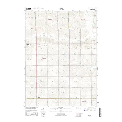
2015 Map of Deep River
USGS Topo · Published 2015About this map
The town of Deep River sits at the western edge of this landscape, serving as a focal point in a region defined by the convergence of Poweshiek, Iowa, and Keokuk counties. The terrain is deeply etched by the winding paths of the North English River and the Middle English River, which create a complex drainage network alongside smaller tributaries like Jordan Cr and Gritter Cr. This map documents a predominantly agricultural area where small settlements like Dresden and Tilton are connected by a grid of county roads including Co HWY f67 and the Diamond Trail Rd. For local historians and genealogists, the map is a vital resource for locating rural burial sites such as the German Methodist Episcopal Cem, Saint Johns Cem, and the Dresden Cem, providing a clear record of the community's established landmarks.
Find a feature on this map
27 named features on this map. Tap any name to fly to it.
Don’t see what you’re looking for? This feature index may not catch every label — zoom into the map to look around manually.
Map Details
Editions of this 2015 Deep River Map
This is the sole edition of this map. No revisions or reprints were ever made.
Other maps of this area

1954 · Des Moines
USGS Topo · 1:250,000

1956 · Des Moines
USGS Topo · 1:250,000

1957 · Des Moines
USGS Topo · 1:250,000

1965 · Gibson
USGS Topo · 1:24,000

1965 · What Cheer
USGS Topo · 1:24,000

1965 · Keswick
USGS Topo · 1:24,000

1968 · Deep River
USGS Topo · 1:24,000

1968 · Brooklyn
USGS Topo · 1:24,000

1968 · Victor
USGS Topo · 1:24,000
1968 · Williamsburg NW
USGS Topo · 1:24,000