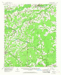
1958 Map of Deep Run
USGS Topo · Published 1968About this map
Neuse River and the Trent River anchor this mid-century portrait of coastal plain North Carolina, where agriculture and early industry define the landscape. The area is marked by a dense network of country churches and family-named crossroads, such as Loftins Crossroads, Nobles Crossroads, and Irvings Crossroads, reflecting the rural social structure of the late 1950s. Near the State Penal Farm and the Kinston Lookout Tower, the topography is punctuated by numerous pocosins and swamps, including the significant Tuckahoe Swamp. Early industry is visible through water-powered sites like Tull Mill and Lawsons Mill, while the presence of the Atlantic and East Carolina RR shows the logistical connections of the era. The map also captures local education hubs like the Deep Run Sch and the Township Sch, providing a clear view of the community footprint before modern consolidation.
Find a feature on this map
93 named features on this map. Tap any name to fly to it.
Don’t see what you’re looking for? This feature index may not catch every label — zoom into the map to look around manually.
Map Details
Editions of this 1958 Deep Run Map
2 editions found

Other maps of this area

1902 · Ayden
USGS Topo · 1:62,500

1903 · Trent River
USGS Topo · 1:62,500

1904 · Ayden
USGS Topo · 1:62,500

1904 · Trent River
USGS Topo · 1:62,500

1914 · Kinston
USGS Topo · 1:48,000

1916 · Kinston
USGS Topo · 1:62,500

1943 · Jacksonville
USGS Topo · 1:62,500

1943 · Kenansville
USGS Topo · 1:62,500

1948 · Kenansville
USGS Topo · 1:62,500

1948 · Richlands
USGS Topo · 1:62,500