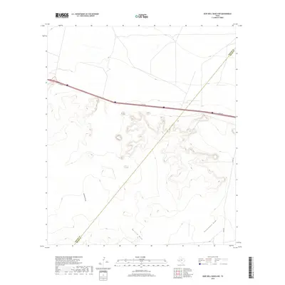
2019 Map of Deep Well Ranch NW
USGS Topo · Published 2019About this map
Barrilla Draw and Lawrence Draw cut through the arid terrain of West Texas, defining the drainage patterns of this sparsely populated corner of the state. Near the southern edge, Schoolhouse Draw suggests the presence of a historical landmark in a region where local watercourses were vital for livestock and early travelers. The landscape is bisected by the county boundary separating Reeves County and Pecos County, a line that runs diagonally across the topography. Modern infrastructure is represented by the I10 Svc Rd, providing access alongside the major interstate corridor, while Hovey Rd tracks along the eastern margin of the sheet. This topographic study captures a rugged intersection of geography where traditional ranching landmarks meet contemporary transportation routes.
Find a feature on this map
6 named features on this map. Tap any name to fly to it.
Don’t see what you’re looking for? This feature index may not catch every label — zoom into the map to look around manually.
Map Details
Editions of this 2019 Deep Well Ranch NW Map
This is the sole edition of this map. No revisions or reprints were ever made.
Other maps of this area

1894 · Fort Davis
USGS Topo · 1:125,000

1897 · Fort Davis
USGS Topo · 1:125,000

1921 · Toyah
USGS Topo · 1:125,000

1929 · Hovey
USGS Topo · 1:125,000

1931 · Barstow
USGS Topo · 1:125,000

1954 · Pecos
USGS Topo · 1:250,000

1954 · Fort Stockton
USGS Topo · 1:250,000

1955 · Saragosa
USGS Topo · 1:62,500

1957 · Pecos
USGS Topo · 1:250,000

1958 · Fort Stockton
USGS Topo · 1:250,000