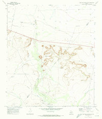
1970 Map of Deep Well Ranch NW
USGS Topo · Published 1973About this map
Deep ephemeral drainages carve the Trans-Pecos landscape on the boundary between Reeves and Pecos Counties. The terrain is defined by the convergence of Barrilla Draw, Lawrence Draw, and Schoolhouse Draw, indicating a landscape shaped by seasonal water flow and livestock ranching. Water management is a central feature of the local economy, evidenced by a network of isolated water sources including the Eclipse Windmill, Chapo Windmill, and Barrilla Windmill. Settlement is sparse, anchored by the Graef Ranch and Hayter Ranch. Infrastructure at this time consists largely of unimproved roads like Hoefs Road and Hovey Road, supporting scattered Oil Wells and a Gravel Pit near the intersection of highway 290. The map captures a moment when traditional ranching and emerging energy extraction coexisted in this arid reach of West Texas.
Find a feature on this map
18 named features on this map. Tap any name to fly to it.
Don’t see what you’re looking for? This feature index may not catch every label — zoom into the map to look around manually.
Map Details
Editions of this 1970 Deep Well Ranch NW Map
This is the sole edition of this map. No revisions or reprints were ever made.
Other maps of this area

1894 · Fort Davis
USGS Topo · 1:125,000

1897 · Fort Davis
USGS Topo · 1:125,000

1921 · Toyah
USGS Topo · 1:125,000

1929 · Hovey
USGS Topo · 1:125,000

1931 · Barstow
USGS Topo · 1:125,000

1954 · Pecos
USGS Topo · 1:250,000

1954 · Fort Stockton
USGS Topo · 1:250,000

1955 · Saragosa
USGS Topo · 1:62,500

1957 · Pecos
USGS Topo · 1:250,000

1958 · Fort Stockton
USGS Topo · 1:250,000