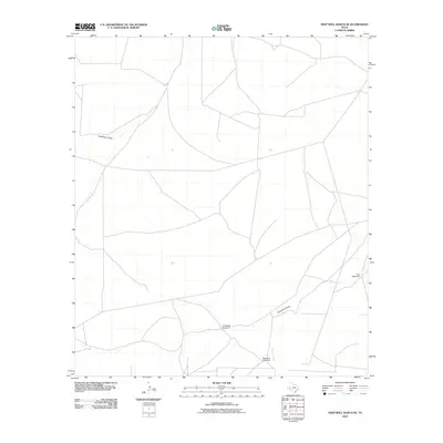
2010 Map of Deep Well Ranch SE
USGS Topo · Published 2010About this map
Hackberry Draw cuts across the arid landscape of Pecos County in this early 21st-century mapping of the West Texas ranchlands. The area is defined by its intermittent drainage systems and critical water infrastructure, essential for supporting livestock in this portion of the Permian Basin. Named water features like Coyanosa Draw and Paisano Creek illustrate the natural topography, while the scattered locations of Cartledge Windmill, Mathews Windmill, and Tule Windmill reveal the human adaptation to the environment. The road network shown here reflects the practical grid of ranch access roads and utility corridors typical of this expansive cattle-raising region, providing a clear record of the area's rural development and land use patterns.
Find a feature on this map
6 named features on this map. Tap any name to fly to it.
Don’t see what you’re looking for? This feature index may not catch every label — zoom into the map to look around manually.
Map Details
Editions of this 2010 Deep Well Ranch SE Map
This is the sole edition of this map. No revisions or reprints were ever made.
Other maps of this area

1929 · Hovey
USGS Topo · 1:125,000

1954 · Fort Stockton
USGS Topo · 1:250,000

1958 · Fort Stockton
USGS Topo · 1:250,000

1970 · Belding SW
USGS Topo · 1:24,000

1970 · Tucker Hill
USGS Topo · 1:24,000

1970 · Deep Well Ranch
USGS Topo · 1:24,000

1970 · Deep Well Ranch SE
USGS Topo · 1:24,000

1970 · Belding NW
USGS Topo · 1:24,000
1970 · Deep Well Ranch NW
USGS Topo · 1:24,000

1973 · Fort Stockton
USGS Topo · 1:250,000