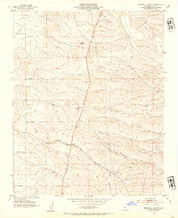
1952 Map of Deepwell Ranch
USGS Topo · Published 1954About this map
The rolling hills of Kern County are defined by isolated ranching outposts and a sparse network of early roadways in the early 1950s. Agricultural life centers on family-named properties like Hodgeman Ranch, Deepwell Ranch, and Villard Ranch, which are connected by a few primary routes such as Mc Farland Woody Road and Peterson Road. The presence of the Jasmin Landing Field in the northwest corner highlights the importance of aviation for remote monitoring and transport in this California landscape. Water drainage patterns are clearly marked by the winding paths of Dyer Creek and Rag Gulch, which cut through the undulating terrain. This survey reflects a specific era before significant modern development, showing the transition of the land from open range to more structured agricultural plots defined by Hart Avenue and Sherwood Ave.
Find a feature on this map
10 named features on this map. Tap any name to fly to it.
Don’t see what you’re looking for? This feature index may not catch every label — zoom into the map to look around manually.
Map Details
Editions of this 1952 Deepwell Ranch Map
3 editions found
Other maps of this area

1906 · Bakersfield
USGS Topo · 1:62,500

1926 · Quincy School
USGS Topo · 1:31,680

1927 · McFarland
USGS Topo · 1:31,680

1929 · Delano
USGS Topo · 1:31,680

1929 · Richgrove
USGS Topo · 1:31,680

1929 · Quincy School
USGS Topo · 1:31,680

1930 · McFarland
USGS Topo · 1:31,680

1930 · Famoso
USGS Topo · 1:31,680

1931 · Deepwell Ranch
USGS Topo · 1:31,680

1932 · North of Oildale
USGS Topo · 1:31,680