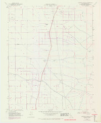
1952 Map of Deepwell Ranch
USGS Topo · Published 1971About this map
Jasmin Landing Field and its surrounding agricultural infrastructure define this section of Kern County during a period of mid-century development. The landscape is organized by a rigid grid of transit corridors, including Hart Ave, Peterson Road, and Sherwood Ave, which support the ranching and resource extraction economy of the region. Local water management is evident through the presence of Dyer Creek and Five Dog Creek, alongside scattered Oil Wells and a Gravel Pit that highlight the area's industrial activity.
Find a feature on this map
13 named features on this map. Tap any name to fly to it.
Don’t see what you’re looking for? This feature index may not catch every label — zoom into the map to look around manually.
Map Details
Editions of this 1952 Deepwell Ranch Map
3 editions found
Other maps of this area

1906 · Bakersfield
USGS Topo · 1:62,500

1926 · Quincy School
USGS Topo · 1:31,680

1927 · McFarland
USGS Topo · 1:31,680

1929 · Delano
USGS Topo · 1:31,680

1929 · Richgrove
USGS Topo · 1:31,680

1929 · Quincy School
USGS Topo · 1:31,680

1930 · McFarland
USGS Topo · 1:31,680

1930 · Famoso
USGS Topo · 1:31,680

1931 · Deepwell Ranch
USGS Topo · 1:31,680

1932 · North of Oildale
USGS Topo · 1:31,680