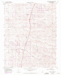
1952 Map of Deepwell Ranch
USGS Topo · Published 1971About this map
The Deepwell Ranch and neighboring Hodgeman Ranch and Villard Ranch anchor this landscape in northwestern Kern County, where the southern San Joaquin Valley meets the rising foothills. Surveyed in 1952 and photorevised in 1969, the map reveals a network of agricultural roads and irrigation infrastructure characteristic of the mid-century valley's expansion. Significant transportation routes including Hart Ave, Peterson Road, and Mc Farland Woody Road partition the land, while the presence of the Jasmin Landing Field and a nearby Gravel Pit highlight the era's local industry and aviation infrastructure. The ephemeral Dyer Creek cuts through the undulating terrain, providing a natural contrast to the rigid grid of property lines and regional thoroughfares like Sherwood Ave.
Find a feature on this map
12 named features on this map. Tap any name to fly to it.
Don’t see what you’re looking for? This feature index may not catch every label — zoom into the map to look around manually.
Map Details
Editions of this 1952 Deepwell Ranch Map
3 editions found
Other maps of this area

1906 · Bakersfield
USGS Topo · 1:62,500

1926 · Quincy School
USGS Topo · 1:31,680

1927 · McFarland
USGS Topo · 1:31,680

1929 · Delano
USGS Topo · 1:31,680

1929 · Richgrove
USGS Topo · 1:31,680

1929 · Quincy School
USGS Topo · 1:31,680

1930 · McFarland
USGS Topo · 1:31,680

1930 · Famoso
USGS Topo · 1:31,680

1931 · Deepwell Ranch
USGS Topo · 1:31,680

1932 · North of Oildale
USGS Topo · 1:31,680