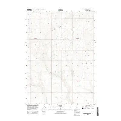
2013 Map of Deer Heaven Mountain
USGS Topo · Published 2013About this map
Deer Heaven Mtn towers over a landscape defined by its vital water sources in this high-altitude corner of Elmore County. The terrain is deeply incised by drainages such as Thorn Cr, King Hill Cr, and Deer Heaven Cr, which carry runoff from the surrounding peaks. This 2013 survey illustrates the critical importance of isolated water points in the high desert, documenting a series of named springs including Bourbon Spring, Whiskey Spring, and Thoroughbred Spring. These features, alongside landmarks like Walker Gulch and the steep Devils Dive, provide essential orientation for navigation through the remote backcountry. The presence of Hill City Rd in the northwestern corner serves as a primary transit link through this otherwise undeveloped Idaho wilderness.
Find a feature on this map
21 named features on this map. Tap any name to fly to it.
Don’t see what you’re looking for? This feature index may not catch every label — zoom into the map to look around manually.
Map Details
Editions of this 2013 Deer Heaven Mountain Map
This is the sole edition of this map. No revisions or reprints were ever made.
Other maps of this area

1892 · Camas Prairie
USGS Topo · 1:125,000

1893 · Camas Prairie
USGS Topo · 1:125,000

1955 · Hailey
USGS Topo · 1:250,000
1958 · Bennett Mtn
USGS Topo · 1:62,500

1958 · King Hill
USGS Topo · 1:62,500

1959 · Hailey
USGS Topo · 1:250,000

1962 · Hailey
USGS Topo · 1:250,000

1963 · High Prairie
USGS Topo · 1:24,000

1963 · Hill City
USGS Topo · 1:24,000
1973 · Cat Creek Summit
USGS Topo · 1:24,000