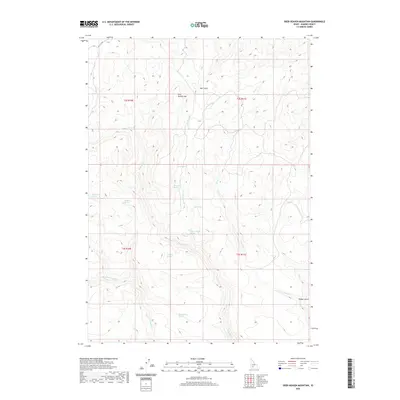
2020 Map of Deer Heaven Mountain
USGS Topo · Published 2020About this map
Deer Heaven Mtn serves as the central landmark for this high-altitude landscape in Elmore County, where a complex network of seasonal drainages and springs defines the terrain. The presence of numerous named water sources, such as Bourbon Spring, Whiskey Spring, and Thoroughbred Spring, suggests a history of range use and critical watering points for livestock and wildlife. These features are tucked into the drainages of Hall Gulch and Walker Gulch, illustrating how water availability dictates the movement through this Idaho upland. Modern access is represented by Hill City Rd in the northwestern corner, providing a link between the remote reaches of King Hill Cr and the broader region. The topography is further etched by the W Fork King Hill Cr and Thorn Cr, showing the intricate erosion patterns typical of the state's interior basins.
Find a feature on this map
20 named features on this map. Tap any name to fly to it.
Don’t see what you’re looking for? This feature index may not catch every label — zoom into the map to look around manually.
Map Details
Editions of this 2020 Deer Heaven Mountain Map
This is the sole edition of this map. No revisions or reprints were ever made.
Other maps of this area

1892 · Camas Prairie
USGS Topo · 1:125,000

1893 · Camas Prairie
USGS Topo · 1:125,000

1955 · Hailey
USGS Topo · 1:250,000
1958 · Bennett Mtn
USGS Topo · 1:62,500

1958 · King Hill
USGS Topo · 1:62,500

1959 · Hailey
USGS Topo · 1:250,000

1962 · Hailey
USGS Topo · 1:250,000

1963 · High Prairie
USGS Topo · 1:24,000

1963 · Hill City
USGS Topo · 1:24,000
1973 · Cat Creek Summit
USGS Topo · 1:24,000