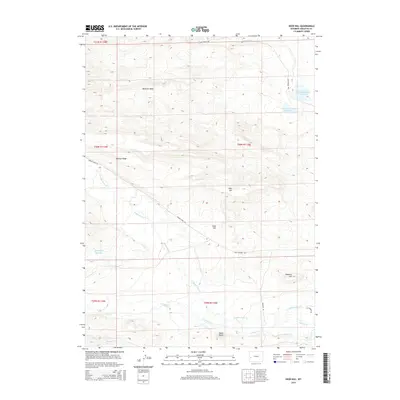
2015 Map of Deer Hill
USGS Topo · Published 2015About this map
McNinch Wash and the high plateaus of Sublette County define this high-altitude landscape, where drainage patterns dictate the placement of ranching infrastructure. Water management is central to this environment, evidenced by the McNinch Number 1 Reservoir and McNinch Number 2 Reservoir in the northeast, alongside the Sphaeralcea Reservoir to the west. These features, combined with the meandering paths of Middle Piney Cr and S Piney Cr, illustrate the critical importance of water conservation in the Wyoming range country.
Find a feature on this map
23 named features on this map. Tap any name to fly to it.
Don’t see what you’re looking for? This feature index may not catch every label — zoom into the map to look around manually.
Map Details
Editions of this 2015 Deer Hill Map
This is the sole edition of this map. No revisions or reprints were ever made.
Other maps of this area

1939 · Big Piney
USGS Topo · 1:125,000

1942 · Big Piney
USGS Topo · 1:125,000

1955 · Preston
USGS Topo · 1:250,000

1958 · Preston
USGS Topo · 1:250,000

1962 · Preston
USGS Topo · 1:250,000

1969 · Chimney Butte
USGS Topo · 1:24,000

1969 · Cretaceous Mountain
USGS Topo · 1:24,000
1969 · Pine Grove Ridge
USGS Topo · 1:24,000
1970 · Budd Reservoir
USGS Topo · 1:24,000
1970 · Big Piney West
USGS Topo · 1:24,000