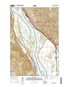
2017 Map of Deer Island
USGS Topo · Published 2017About this map
The Columbia River forms a wide, complex boundary between Oregon and Washington in this 2017 survey, defining the industrial and natural character of the region. The river is a corridor of active commerce, featuring the BNSF Railway and the Bybee Ledge Channel which facilitate transport through the valley. Along the banks, settlements like Columbia City and Woodland are connected by a network of roads including Old 99, while landforms like Deer Island and Martin Island divide the primary flow from numerous sloughs and side channels.
Find a feature on this map
133 named features on this map. Tap any name to fly to it.
Don’t see what you’re looking for? This feature index may not catch every label — zoom into the map to look around manually.
Map Details
Editions of this 2017 Deer Island Map
This is the sole edition of this map. No revisions or reprints were ever made.
Other maps of this area

1921 · Kalama
USGS Topo · 1:62,500

1922 · St. Helens
USGS Topo · 1:62,500

1940 · La Center
USGS Topo · 1:62,500

1941 · St Helens
USGS Topo · 1:62,500

1943 · Pigeon Springs
USGS Topo · 1:62,500

1943 · St Helens
USGS Topo · 1:62,500

1948 · Vancouver
USGS Topo · 1:250,000

1950 · Vancouver
USGS Topo · 1:250,000

1950 · Vancouver
USGS Topo · 1:250,000

1953 · Hoquiam
USGS Topo · 1:250,000