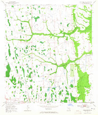
1953 Map of Deer Park NW
USGS Topo · Published 1965About this map
Wolf Creek and Pennywash Creek snake through a landscape of wetlands and pine flatwoods in this mid-century survey of Osceola County. The terrain is defined by its low-lying hydrology, where numerous unnamed ponds and cypress heads dot the interior. A notable mark of past industrial activity is the Old Railroad Grade cutting across the northern sections, suggesting a legacy of timber or phosphate transit that preceded the modern road network. The only significant settlement activity captured is at Orlando Ranch in the eastern portion of the quadrangle. Compiled in part from aerial photography by the U.S. Corps of Engineers, the map provides a precise record of the natural drainage and early cattle ranching footprint before later 20th-century developments altered the Central Florida interior.
Find a feature on this map
6 named features on this map. Tap any name to fly to it.
Don’t see what you’re looking for? This feature index may not catch every label — zoom into the map to look around manually.
Map Details
Editions of this 1953 Deer Park NW Map
4 editions found
Other maps of this area

1953 · Lake Poinsett
USGS Topo · 1:24,000

1953 · Deer Park NE
USGS Topo · 1:24,000

1953 · Holopaw SE
USGS Topo · 1:24,000

1953 · Deer Park SE
USGS Topo · 1:24,000

1953 · Narcoossee SE
USGS Topo · 1:24,000

1953 · Deer Park NW
USGS Topo · 1:24,000

1953 · Lake Poinsett SW
USGS Topo · 1:24,000

1953 · Deer Park
USGS Topo · 1:24,000

1953 · Holopaw
USGS Topo · 1:24,000

1955 · Orlando
USGS Topo · 1:250,000