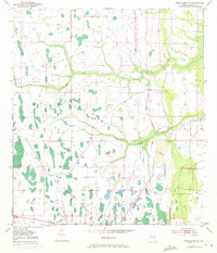
1953 Map of Deer Park NW
USGS Topo · Published 1972About this map
Wolf Creek and Pennywash Creek wind through this part of the Florida interior, defining a landscape of wetlands and scattered hammocks. The area is marked by the path of an Old Railroad Grade, which speaks to an era of earlier extraction or transport before being reclaimed by the scrub and swamp. In the eastern portion of the quadrangle, Orlando Ranch stands as the primary named settlement, surrounded by a network of drainage canals and unimproved dirt roads that reflect the transition of the land for agricultural or ranching use. Revisions made in 1970 show the gradual expansion of roads and small structures in this Osceola County territory, though the hydrological patterns of the creeks remain the dominant geographic influence.
Find a feature on this map
6 named features on this map. Tap any name to fly to it.
Don’t see what you’re looking for? This feature index may not catch every label — zoom into the map to look around manually.
Map Details
Editions of this 1953 Deer Park NW Map
4 editions found
Other maps of this area

1953 · Lake Poinsett
USGS Topo · 1:24,000

1953 · Deer Park NE
USGS Topo · 1:24,000

1953 · Holopaw SE
USGS Topo · 1:24,000

1953 · Deer Park SE
USGS Topo · 1:24,000

1953 · Narcoossee SE
USGS Topo · 1:24,000

1953 · Deer Park NW
USGS Topo · 1:24,000

1953 · Lake Poinsett SW
USGS Topo · 1:24,000

1953 · Deer Park
USGS Topo · 1:24,000

1953 · Holopaw
USGS Topo · 1:24,000

1955 · Orlando
USGS Topo · 1:250,000