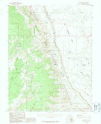
1987 Map of Deer Point
USGS Topo · Published 1987About this map
Waterpocket Fold dominates this 1987 study of the Garfield County backcountry, showcasing the dramatic monocline that defines the boundary between Capitol Reef National Park and the Glen Canyon National Recreation Area. The landscape is a complex network of drainage and elevation, where Halls Creek carves a deep path alongside the Circle Cliffs. Notable landmarks like the Brimhall Double Arch and the Halls Creek Overlook provide specific points of reference for navigating the vertical terrain. Small water sources, critical for the area's history, are documented through labels such as Dove Spring, Burts Spring, and Fountain Tanks. Further south, the map details the descent toward Hall Divide and the branching paths of East Moody Canyon, reflecting the intricate geological erosion of the Big Thompson Mesa.
Find a feature on this map
26 named features on this map. Tap any name to fly to it.
Don’t see what you’re looking for? This feature index may not catch every label — zoom into the map to look around manually.
Map Details
Editions of this 1987 Deer Point Map
2 editions found
Other maps of this area

1886 · Escalante
USGS Topo · 1:250,000

1886 · Henry Mountains
USGS Topo · 1:250,000

1892 · Henry Mountains
USGS Topo · 1:250,000

1953 · Mt Pennell
USGS Topo · 1:62,500

1953 · Circle Cliffs 1 SE
USGS Topo · 1:24,000

1953 · Mt Pennell 2 SE
USGS Topo · 1:24,000

1953 · Mt Pennell 3 NW
USGS Topo · 1:24,000

1953 · Mt Pennell 3 SW
USGS Topo · 1:24,000

1953 · Mt Pennell 2 SW
USGS Topo · 1:24,000

1953 · Circle Cliffs 4 NE
USGS Topo · 1:24,000