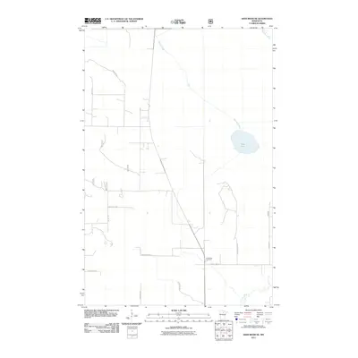
2011 Map of Deer River NE
USGS Topo · Published 2011About this map
Pine Ridge Cemetery sits as a central landmark in this portion of Itasca County, located near the junction of County Hwy-19 and Baumgarner Rd. The landscape is defined by its water systems, including the Bowstring River in the northeast and the Deer River winding through the southern reaches. These waterways, along with Grouse Creek and Evans Creek, illustrate the low-lying, well-watered character of the region.
Find a feature on this map
17 named features on this map. Tap any name to fly to it.
Don’t see what you’re looking for? This feature index may not catch every label — zoom into the map to look around manually.
Map Details
Editions of this 2011 Deer River NE Map
This is the sole edition of this map. No revisions or reprints were ever made.
Other maps of this area

1919 · Marcell
USGS Topo · 1:62,500

1953 · Cohasset West
USGS Topo · 1:24,000

1954 · Hibbing
USGS Topo · 1:250,000

1957 · Hibbing
USGS Topo · 1:250,000

1958 · Hibbing
USGS Topo · 1:250,000

1964 · Hibbing
USGS Topo · 1:250,000

1970 · Bowstring Lake
USGS Topo · 1:24,000

1970 · Deer River NE
USGS Topo · 1:24,000

1970 · Jessie Lake
USGS Topo · 1:24,000
1970 · Deer River
USGS Topo · 1:24,000