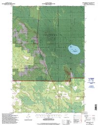
1996 Map of Deer River NE
USGS Topo · Published 1998About this map
The Leech Lake Indian Reservation Boundary cuts a diagonal path across this northern landscape, marking a significant intersection of jurisdictional and natural boundaries in Itasca County. The terrain is defined by the overlapping reaches of the Chippewa National Forest and Bowstring State Forest, where wetlands and forested tracts dominate the topography. Near the center, a small Townhall and the Evans locality represent the quiet civic life of the area during the late twentieth century. In the eastern portion, the Rice Lake State Waterfowl Refuge serves as a protected sanctuary for local wildlife, while the Pine Ridge Cemetery in the south provides a tangible link for those researching local family histories and early residents. This survey also records the industrial footprint of the era through several Gravel Pit locations and the Deer River Marcell road.
Find a feature on this map
10 named features on this map. Tap any name to fly to it.
Don’t see what you’re looking for? This feature index may not catch every label — zoom into the map to look around manually.
Map Details
Editions of this 1996 Deer River NE Map
This is the sole edition of this map. No revisions or reprints were ever made.
Other maps of this area

1919 · Marcell
USGS Topo · 1:62,500

1953 · Cohasset West
USGS Topo · 1:24,000

1954 · Hibbing
USGS Topo · 1:250,000

1957 · Hibbing
USGS Topo · 1:250,000

1958 · Hibbing
USGS Topo · 1:250,000

1964 · Hibbing
USGS Topo · 1:250,000

1970 · Bowstring Lake
USGS Topo · 1:24,000

1970 · Deer River NE
USGS Topo · 1:24,000

1970 · Jessie Lake
USGS Topo · 1:24,000
1970 · Deer River
USGS Topo · 1:24,000