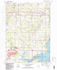
1994 Map of Deerfield
USGS Topo · Published 1997About this map
Berlin Lake and its extensive shoreline dominate the southern landscape of this 1994 survey, reflecting a region defined by water management and rural industry. The area around Deerfield and Palmyra maintains its historical layout, with numerous family and community burial grounds such as Mottown Cem and Robinson Cem preserved across the townships. The transition from agricultural use to resource extraction is evident in the Strip Mine operations near Atwater and the Claypit located north of Diamond. Infrastructure like the Pipeline corridors and the prominent Interchange 48 cut through the traditional road network of Edinburg and Palmyra. This survey captures the rural character of southeastern Portage County just as modern suburban influence began to interface with the established coal and clay extraction sites of the Mahoning Valley.
Find a feature on this map
46 named features on this map. Tap any name to fly to it.
Don’t see what you’re looking for? This feature index may not catch every label — zoom into the map to look around manually.
Map Details
Editions of this 1994 Deerfield Map
This is the sole edition of this map. No revisions or reprints were ever made.
Other maps of this area

1906 · Ravenna
USGS Topo · 1:62,500

1908 · Warren
USGS Topo · 1:62,500

1908 · Ravenna
USGS Topo · 1:62,500

1909 · Alliance
USGS Topo · 1:62,500

1909 · Lisbon
USGS Topo · 1:62,500

1950 · Cleveland
USGS Topo · 1:250,000

1951 · Canton
USGS Topo · 1:250,000

1952 · Lake Milton
USGS Topo · 1:24,000

1952 · Alliance
USGS Topo · 1:24,000

1952 · Damascus
USGS Topo · 1:24,000