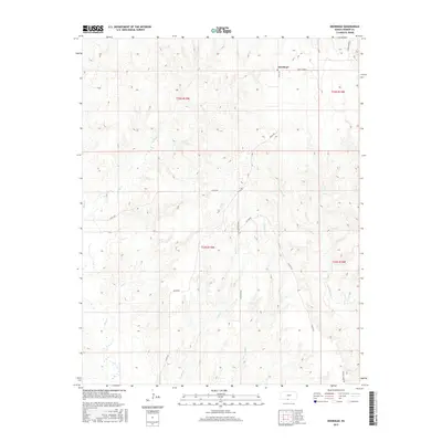
2015 Map of Deerhead
USGS Topo · Published 2015About this map
Deerhead serves as the focal point for this section of Barber County, situated amidst a complex network of seasonal drainages and rural corridors. The landscape is defined by the hydrologic branching of Mule Cr, Ash Cr, and the parallel paths of W Dry Cr and E Dry Cr. These waterways dictate the placement of local thoroughfares such as Aetna Rd and Estill Rd, which navigate the terrain alongside lesser-known routes like Crazy Horse. The map details a region where traditional section-line boundaries, including t32s r15w and t33s r15w, overlay a topography primarily utilized for ranching or agriculture. This 2015 survey provides a modern spatial perspective on the enduring rural structure of south-central Kansas, highlighting how contemporary names like Sunnyside Rd and Cottage Creek Rd continue to organize the sparsely populated prairie environment.
Find a feature on this map
18 named features on this map. Tap any name to fly to it.
Don’t see what you’re looking for? This feature index may not catch every label — zoom into the map to look around manually.
Map Details
Editions of this 2015 Deerhead Map
This is the sole edition of this map. No revisions or reprints were ever made.
Other maps of this area

1891 · Medicine Lodge
USGS Topo · 1:125,000

1892 · Coldwater
USGS Topo · 1:125,000

1893 · Medicine Lodge
USGS Topo · 1:125,000

1955 · Pratt
USGS Topo · 1:250,000

1959 · Pratt
USGS Topo · 1:250,000

1968 · Sun City SW
USGS Topo · 1:24,000

1968 · Wilmore SE
USGS Topo · 1:24,000
1973 · Pump Creek
USGS Topo · 1:24,000
1973 · Deerhead
USGS Topo · 1:24,000
1973 · Lake City
USGS Topo · 1:24,000