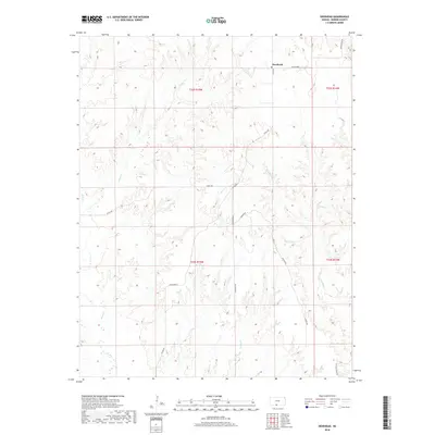
2018 Map of Deerhead
USGS Topo · Published 2018About this map
Deerhead serves as the focal point for this section of Barber County, situated at the junction of Aetna Rd and Crazy Horse. The landscape is defined by a dendritic drainage pattern where intermittent streams such as Inman Cr, Deadman Cr, and Ash Cr have carved the terrain into complex ridges and valleys. This 2018 survey reveals a sparse network of section roads that follow the high ground and canyon floors, including Sunnyside Rd and Canyon Rd. The presence of W Dry Cr and E Dry Cr highlights the seasonal nature of the local hydrography, typical of the High Plains transition. For genealogists and land historians, the map provides precise section, township, and range boundaries across T32S and T33S, anchoring local family landholdings to the physical geography of the Kansas prairie.
Find a feature on this map
18 named features on this map. Tap any name to fly to it.
Don’t see what you’re looking for? This feature index may not catch every label — zoom into the map to look around manually.
Map Details
Editions of this 2018 Deerhead Map
This is the sole edition of this map. No revisions or reprints were ever made.
Other maps of this area

1891 · Medicine Lodge
USGS Topo · 1:125,000

1892 · Coldwater
USGS Topo · 1:125,000

1893 · Medicine Lodge
USGS Topo · 1:125,000

1955 · Pratt
USGS Topo · 1:250,000

1959 · Pratt
USGS Topo · 1:250,000

1968 · Sun City SW
USGS Topo · 1:24,000

1968 · Wilmore SE
USGS Topo · 1:24,000
1973 · Pump Creek
USGS Topo · 1:24,000
1973 · Deerhead
USGS Topo · 1:24,000
1973 · Lake City
USGS Topo · 1:24,000