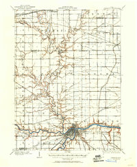
1986 Map of Defiance
USGS Topo · Published 1992About this map
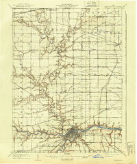
The Maumee River and Auglaize River meet at the heart of this Northwest Ohio region, defining the orientation of settlements and industry in the late 1980s. In Defiance, the presence of Defiance College and Riverside Cem marks the local cultural landscape, while the Norfolk and Western RR provides the primary industrial infrastructure through the corridor. Further east, the river system supports recreational areas like Independence Dam State Park and Mary Jane Thurston State Park near Napoleon. The map captures a transition from concentrated river towns to the broad, gridded agricultural expanses of Paulding and Putnam counties. Smaller communities such as Antwerp, Hicksville, and Ottawa anchor the surrounding rural landscape, connected by a network of waterways including Flatrock Creek and the Tiffin River.
Find a feature on this map
111 named features on this map. Tap any name to fly to it.
Don’t see what you’re looking for? This feature index may not catch every label — zoom into the map to look around manually.
Map Details
Editions of this 1986 Defiance Map
This is the sole edition of this map. No revisions or reprints were ever made.
Historical Maps of Defiance Through Time
3 maps found