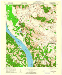
1959 Map of Dekoven
USGS Topo · Published 1960About this map
The Ohio River dominates this landscape, serving as the border between Union County, Kentucky, and the Shawnee National Forest in Illinois. In the late 1950s, this riverine economy was tied to the Illinois Central railroad, which connected settlements like Henshaw and Dekoven across the undulating terrain of the Chapel Hills and Paris Hills. The map captures a detailed view of small communities and rural life, featuring landmarks such as Caseyville and Mulfordtown along the riverbanks, and Bells Mines tucked further inland. Notable for genealogists are several small burial grounds and houses of worship, including St Ambrose Ch, Bells Mines Ch, and the Odd Fellows Cem. The presence of the Tradewater River and O'Nan Ditch illustrates the complex drainage and historical reliance on local water systems for both agriculture and transportation.
Find a feature on this map
51 named features on this map. Tap any name to fly to it.
Don’t see what you’re looking for? This feature index may not catch every label — zoom into the map to look around manually.
Map Details
Editions of this 1959 Dekoven Map
3 editions found
Other maps of this area

1907 · Morganfield
USGS Topo · 1:62,500

1909 · Providence
USGS Topo · 1:62,500

1916 · Shawneetown
USGS Topo · 1:62,500

1916 · Fords Ferry
USGS Topo · 1:62,500

1921 · Fords Ferry
USGS Topo · 1:48,000

1925 · Cave In Rock
USGS Topo · 1:62,500

1949 · Paducah
USGS Topo · 1:250,000

1949 · Morganfield
USGS Topo · 1:24,000

1950 · Paducah
USGS Topo · 1:250,000

1951 · Sturgis
USGS Topo · 1:24,000