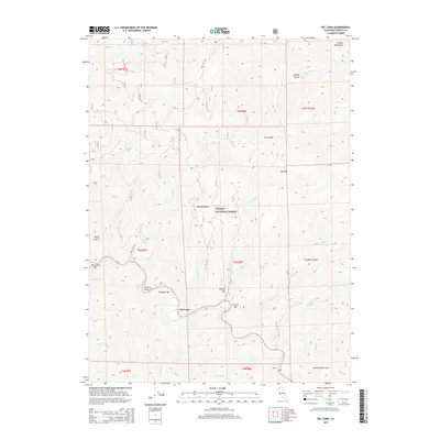
2015 Map of Del Loma
USGS Topo · Published 2015About this map
The Trinity River snakes through the heart of this landscape, carving deep valleys between the high peaks of the Salmon Mountains and Barnum Ridge. Along its banks, the river's legacy of mining and settlement is evident in names like Schneiders Bar, Canadian Bar, and French Bar, marking sites where alluvial deposits once drew prospectors. The small settlement of Del Loma serves as a focal point along the waterway, positioned near Tonys Point and Taylors Flat. This 2015 survey shows a terrain defined by its complex drainage network, where Big French Cr and Little French Cr feed the main river corridor. High-elevation points like Cherry Flat and Oak Flat stand in contrast to the steep drainage of Vance Gulch, while Forest Rte 4 and Swede Creek Rd provide the primary access into the steep forested interior.
Find a feature on this map
38 named features on this map. Tap any name to fly to it.
Don’t see what you’re looking for? This feature index may not catch every label — zoom into the map to look around manually.
Map Details
Editions of this 2015 Del Loma Map
This is the sole edition of this map. No revisions or reprints were ever made.
Other maps of this area

1909 · Big Bar
USGS Topo · 1:96,000

1915 · Big Bar and Vicinity
USGS Topo · 1:250,000

1951 · Hayfork
USGS Topo · 1:62,500

1951 · Helena
USGS Topo · 1:62,500

1951 · Hyampom
USGS Topo · 1:62,500

1951 · Ironside Mountain
USGS Topo · 1:62,500

1958 · Redding
USGS Topo · 1:250,000
1982 · Jim Jam Ridge
USGS Topo · 1:24,000
1982 · Denny
USGS Topo · 1:24,000

1982 · Helena
USGS Topo · 1:24,000