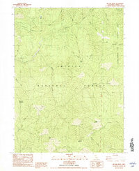
1982 Map of Jim Jam Ridge
USGS Topo · Published 1982About this map
Miller Ranch and a network of high-elevation campsites define this reach of the Trinity National Forest in the early 1980s. The landscape is dominated by the massive Jim Jam Ridge and the Salmon-Trinity Alps Primitive Area, where the New River and its many tributaries, including Bake Oven Creek and Whisky Creek, carve through the terrain. A footbridge crosses the East Fork New River near Fall Creek, while numerous jeep and foot trails connect seasonal outposts like Jakes Hunting Ground and Hailstone Camp. The naming conventions here, from Jim Jam Spring to Beartooth Mountain, reflect a legacy of local hunting and ranching culture that persisted even as federal oversight solidified the region's status as a wilderness primitive area.
Find a feature on this map
38 named features on this map. Tap any name to fly to it.
Don’t see what you’re looking for? This feature index may not catch every label — zoom into the map to look around manually.
Map Details
Editions of this 1982 Jim Jam Ridge Map
This is the sole edition of this map. No revisions or reprints were ever made.
Other maps of this area

1909 · Big Bar
USGS Topo · 1:96,000

1915 · Big Bar and Vicinity
USGS Topo · 1:250,000

1948 · Weed
USGS Topo · 1:250,000

1950 · Weed
USGS Topo · 1:250,000

1951 · Helena
USGS Topo · 1:62,500

1951 · Ironside Mountain
USGS Topo · 1:62,500

1955 · Salmon Mtn
USGS Topo · 1:62,500

1955 · Cecilville
USGS Topo · 1:62,500

1958 · Redding
USGS Topo · 1:250,000

1958 · Weed
USGS Topo · 1:250,000