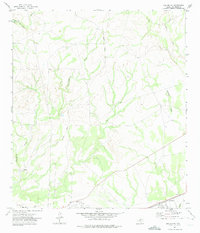
1972 Map of Del Rio NE
USGS Topo · Published 1975About this map
Laughlin Air Force Base dominates the southeastern corner of this landscape, marking the military presence near the border in the early 1970s. The terrain is defined by the deep incisions of San Felipe Creek and San Pedro Creek, which channel toward the newly established Amistad Reservoir at the northwestern edge. A prominent Old Railroad Grade snakes through the central hills, tracing a bypassed transportation corridor that once linked the regional ranchlands. Near the southern boundary, the small settlement of Johnstone sits adjacent to the airfield, while scattered Gravel Pit sites indicate local extractive activity. The map captures a moment when traditional land use, represented by the winding Sycamore Creek, met the modern infrastructure of the reservoir and the expanding air force installations.
Find a feature on this map
9 named features on this map. Tap any name to fly to it.
Don’t see what you’re looking for? This feature index may not catch every label — zoom into the map to look around manually.
Map Details
Editions of this 1972 Del Rio NE Map
This is the sole edition of this map. No revisions or reprints were ever made.
Other maps of this area

1941 · Standart
USGS Topo · 1:62,500

1943 · Standart
USGS Topo · 1:62,500

1943 · Del Rio
USGS Topo · 1:62,500

1944 · Flat Rock
USGS Topo · 1:62,500

1944 · Devils Lake
USGS Topo · 1:62,500

1958 · Del Rio
USGS Topo · 1:250,000

1964 · Del Rio
USGS Topo · 1:250,000

1972 · Del Rio SW
USGS Topo · 1:24,000

1972 · Rough Canyon SE
USGS Topo · 1:24,000

1972 · Del Rio SE
USGS Topo · 1:24,000