
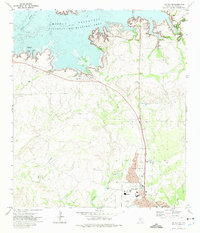
1972 Map of Del Rio SE
USGS Topo · Published 1975About this map
The international boundary along the Rio Grande dominates the southern reaches of this 1972 survey, where the river carves a winding path between the United States and Mexico. On the Texas side, the landscape is defined by the heavy infrastructure of Laughlin Air Force Base, showing its complex of runways, a Hospital, and a Golf Course during the early 1970s. This era of cold war operations is juxtaposed against the older transportation corridors of the Southern Pacific railroad and early streets like E Adobe St in the southeastern edge of Del Rio. Significant topographical features such as Eagle Pass Hill and the drainage patterns of Sacatosa Creek and Zorro Creek illustrate the arid, dissected terrain of Val Verde County. From the industrial Gravel Pits to the quiet grounds of Oaklawn Memorial Park, the map captures a specific moment of military expansion and regional development near the border.
Find a feature on this map
33 named features on this map. Tap any name to fly to it.
Don’t see what you’re looking for? This feature index may not catch every label — zoom into the map to look around manually.
Map Details
Editions of this 1972 Del Rio SE Map
This is the sole edition of this map. No revisions or reprints were ever made.
Other maps of this area

1941 · Standart
USGS Topo · 1:62,500

1941 · Tequesquite Creek
USGS Topo · 1:62,500

1943 · Standart
USGS Topo · 1:62,500

1943 · Del Rio
USGS Topo · 1:62,500

1944 · Sycamore Ranch
USGS Topo · 1:62,500

1944 · Tequesquite Creek
USGS Topo · 1:62,500

1958 · Del Rio
USGS Topo · 1:250,000

1964 · Del Rio
USGS Topo · 1:250,000

1972 · Del Rio SW
USGS Topo · 1:24,000
1972 · Del Rio NW
USGS Topo · 1:24,000