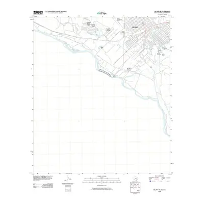
2010 Map of Del Rio SW
USGS Topo · Published 2010About this map
The Rio Grande serves as the international boundary between the United States and Mexico, carving a winding path through this border landscape. In Del Rio, the urban grid extends toward the river, connected by the International Bridge and anchored by the Del Rio International Airport. The map highlights a series of residential developments known as colonias, including Cienegas Terrace and Rio Bravo, which sit alongside established local sites like the Old San Felipe Cemetery and Westlawn Cemetery. Natural hydrology is a defining feature, with San Felipe Creek, Cienegas Creek, and Salt Creek draining toward the main river channel. This 2010 survey provides a detailed look at the infrastructure and topography of the Texas-Coahuila borderlands, from the rise of Round Mountain to the network of local routes like Old Foster Rd and Vega Verde.
Find a feature on this map
30 named features on this map. Tap any name to fly to it.
Don’t see what you’re looking for? This feature index may not catch every label — zoom into the map to look around manually.
Map Details
Editions of this 2010 Del Rio SW Map
This is the sole edition of this map. No revisions or reprints were ever made.
Other maps of this area

1943 · Devils River
USGS Topo · 1:62,500

1943 · Del Rio
USGS Topo · 1:62,500

1944 · Sycamore Ranch
USGS Topo · 1:62,500

1944 · Devils River
USGS Topo · 1:62,500

1958 · Del Rio
USGS Topo · 1:250,000

1964 · Del Rio
USGS Topo · 1:250,000

1972 · Amistad Dam
USGS Topo · 1:24,000

1972 · Del Rio SW
USGS Topo · 1:24,000

1972 · Del Rio SE
USGS Topo · 1:24,000
1972 · Del Rio NW
USGS Topo · 1:24,000