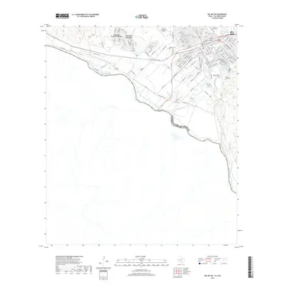
2019 Map of Del Rio SW
USGS Topo · Published 2019About this map
The Rio Grande serves as both a geographic boundary and a central corridor in this border region, separating the United States of America and Mexico. On the northern bank, the city of Del Rio is anchored by the historic San Felipe Springs and the winding San Felipe Creek. This 2019 survey documents the extensive residential layout of the Cienegas Terrace Colonia and the commercial infrastructure surrounding the Del Rio International Airport. The International Bridge provides the primary crossing point between the two nations, while the Southern Pacific railroad lines reflect the long-standing importance of this hub as a transit point. Local heritage is preserved in the grounds of the Old San Felipe Cem and Westlawn Cem, which sit near the prominent landmark of Round Mtn.
Find a feature on this map
156 named features on this map. Tap any name to fly to it.
Don’t see what you’re looking for? This feature index may not catch every label — zoom into the map to look around manually.
Map Details
Editions of this 2019 Del Rio SW Map
This is the sole edition of this map. No revisions or reprints were ever made.
Other maps of this area

1943 · Devils River
USGS Topo · 1:62,500

1943 · Del Rio
USGS Topo · 1:62,500

1944 · Sycamore Ranch
USGS Topo · 1:62,500

1944 · Devils River
USGS Topo · 1:62,500

1958 · Del Rio
USGS Topo · 1:250,000

1964 · Del Rio
USGS Topo · 1:250,000

1972 · Amistad Dam
USGS Topo · 1:24,000

1972 · Del Rio SW
USGS Topo · 1:24,000

1972 · Del Rio SE
USGS Topo · 1:24,000
1972 · Del Rio NW
USGS Topo · 1:24,000