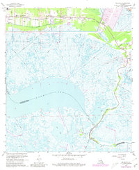
1967 Map of Delacroix
USGS Topo · Published 1980About this map
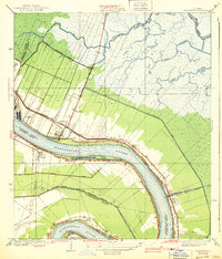
St Bernard and the surrounding marshlands of the lower Mississippi delta are defined by an intricate network of drainage and transportation canals that supported the region's mid-century expansion. The landscape is bisected by the Southern Railroad and Bayou Terre aux Boeufs, where linear settlements like Toca, Kenilworth, and Verret hug the higher ground of the natural levees. To the south, Lake Lery and Lost Lake dominate a watery expanse crisscrossed by numerous waterways such as the Forty Arpent Canal and Magnolia Canal. This survey captures the transition of the marsh, showing a Control Structure Under Construction and significant spoil areas that reflect ongoing hydrological engineering and land reclamation efforts. Local history is anchored by landmarks such as Creedmore Ch, True Love Cem, and the St Bernard High Sch, marking the cultural centers of these tight-knit bayou communities.
Find a feature on this map
42 named features on this map. Tap any name to fly to it.
Don’t see what you’re looking for? This feature index may not catch every label — zoom into the map to look around manually.
Map Details
Editions of this 1967 Delacroix Map
4 editions found
Other maps of this area

1891 · Pointe a La Hache
USGS Topo · 1:62,500

1892 · St. Bernard
USGS Topo · 1:62,500

1892 · Pointe a La Hache
USGS Topo · 1:62,500

1893 · Shell Beach
USGS Topo · 1:62,500

1893 · Dime
USGS Topo · 1:62,500

1935 · Delacroix
USGS Topo · 1:31,680

1935 · Lake Batola
USGS Topo · 1:31,680

1939 · Shell Beach
USGS Topo · 1:62,500
1939 · Chalmette
USGS Topo · 1:31,680

1939 · Pointe a La Hache
USGS Topo · 1:62,500