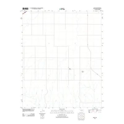
2012 Map of Delhi
USGS Topo · Published 2012About this map
Delhi serves as the focal point for this section of Beckham County, an area defined by the systematic section lines of the Oklahoma prairie. The landscape is primarily agricultural, punctuated by a series of north-south flowing creek beds that shape the local drainage and land use. For those documenting local lineages or township history, the Delhi Cem provides a specific point of genealogical interest just south of the main settlement. Further east, the Sayre Municipal Airport represents the most significant modern infrastructure on the map, illustrating how transportation needs in the region have evolved from rural roads to aviation. This survey from the U.S. Geological Survey captures the persistent rural character of the southern High Plains during the early 21st century.
Find a feature on this map
3 named features on this map. Tap any name to fly to it.
Don’t see what you’re looking for? This feature index may not catch every label — zoom into the map to look around manually.
Map Details
Editions of this 2012 Delhi Map
This is the sole edition of this map. No revisions or reprints were ever made.
Other maps of this area

1955 · Clinton
USGS Topo · 1:250,000

1957 · Clinton
USGS Topo · 1:250,000

1960 · Sweetwater
USGS Topo · 1:62,500

1960 · Sayre
USGS Topo · 1:62,500

1961 · Willow
USGS Topo · 1:62,500

1961 · Erick
USGS Topo · 1:62,500

1985 · Elk City
USGS Topo · 1:100,000
1989 · Willow
USGS Topo · 1:24,000
1989 · Carter West
USGS Topo · 1:24,000
1989 · Erick
USGS Topo · 1:24,000