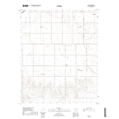
2018 Map of Delhi
USGS Topo · Published 2018About this map
Delhi and its surroundings in western Oklahoma are defined by a network of seasonal watercourses and a strict section-line road system. The settlement sits at the intersection of several local routes, anchored by the nearby Delhi Cem. To the east, the Sayre Municipal Airport represents a significant modern landmark amidst the agricultural landscape. The terrain is deeply etched by a series of creeks, including Turkey Cr in the northwest, Sand Cr through the center, and Spring Cr to the east, which all converge into the broader drainage patterns of the region. In the southern portion of the quadrangle, Haystack Cr and Minnow Creek traverse the land, illustrating the vital role of these small waterways in the local environment and settlement history.
Find a feature on this map
37 named features on this map. Tap any name to fly to it.
Don’t see what you’re looking for? This feature index may not catch every label — zoom into the map to look around manually.
Map Details
Editions of this 2018 Delhi Map
This is the sole edition of this map. No revisions or reprints were ever made.
Other maps of this area

1955 · Clinton
USGS Topo · 1:250,000

1957 · Clinton
USGS Topo · 1:250,000

1960 · Sweetwater
USGS Topo · 1:62,500

1960 · Sayre
USGS Topo · 1:62,500

1961 · Willow
USGS Topo · 1:62,500

1961 · Erick
USGS Topo · 1:62,500

1985 · Elk City
USGS Topo · 1:100,000
1989 · Willow
USGS Topo · 1:24,000
1989 · Carter West
USGS Topo · 1:24,000
1989 · Erick
USGS Topo · 1:24,000