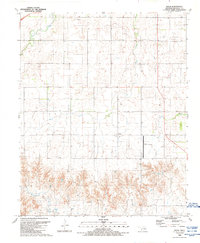
1989 Map of Delhi
USGS Topo · Published 1989About this map
Delhi and its surrounding Beckham County landscape are defined here by a transition from the drainage basins of Turkey Creek and Sand Creek in the north to the more dissected terrain of Haystack Creek in the south. The rural settlement pattern is anchored by the small community of Delhi, marked by its local Cem, and is heavily influenced by the region's energy infrastructure. Numerous petroleum and natural gas features, including an extensive Gas Storage Area, various Oil Wells, and a prominent Pipeline, illustrate the industrial character of the Oklahoma plains during the late twentieth century. Transportation and utility landmarks such as the Sayre Municipal Airport, equipped with a Beacon, and a local Water Tank, provide essential reference points for researchers tracing the development of this agricultural and energy-producing corridor.
Find a feature on this map
16 named features on this map. Tap any name to fly to it.
Don’t see what you’re looking for? This feature index may not catch every label — zoom into the map to look around manually.
Map Details
Editions of this 1989 Delhi Map
This is the sole edition of this map. No revisions or reprints were ever made.
Other maps of this area

1955 · Clinton
USGS Topo · 1:250,000

1957 · Clinton
USGS Topo · 1:250,000

1960 · Sweetwater
USGS Topo · 1:62,500

1960 · Sayre
USGS Topo · 1:62,500

1961 · Willow
USGS Topo · 1:62,500

1961 · Erick
USGS Topo · 1:62,500

1985 · Elk City
USGS Topo · 1:100,000
1989 · Willow
USGS Topo · 1:24,000
1989 · Carter West
USGS Topo · 1:24,000
1989 · Erick
USGS Topo · 1:24,000